2020 Hurricane Season
Moderators: Bakhtosh, EvilHomer3k
-
gilraen

- Posts: 4317
- Joined: Wed Sep 04, 2013 7:45 pm
- Location: Broomfield, CO
Re: 2020 Hurricane Season
20mph is considered a pretty fast-moving storm, so maybe they calculated that it won't get a chance to absorb enough heat to strengthen. Now, if it slowed down for some reason...that would be a problem.
-
jztemple2

- Posts: 11602
- Joined: Fri Feb 13, 2009 7:52 am
- Location: Brevard County, Florida, USA
Re: 2020 Hurricane Season
11pm EDT update. The leftward/southward shift of the track continues, taking TS Laura directly across Hispaniola and Cuba. That should take the stuffing out of the storm before it enters the Gulf. The big question is how much re-intensification will take place as it crosses the Gulf.

And it looks like Marco will be going ashore near Galveston a day before Laura shows up at New Orleans.

And it looks like Marco will be going ashore near Galveston a day before Laura shows up at New Orleans.
My father said that anything is interesting if you bother to read about it - Michael C. Harrold
-
jztemple2
- Posts: 11602
- Joined: Fri Feb 13, 2009 7:52 am
- Location: Brevard County, Florida, USA
Re: 2020 Hurricane Season
This is an interesting article over on Yale Climate Connections by Dr Jeff Masters, one of those tropical storm gurus, Tropical Storm Laura and Tropical Depression 14 predicted to converge in Gulf of Mexico . The article is subtitled "The two storms may undergo a rare phenomenon known as the Fujiwara effect" which is I believe how Kirk beat the Romulans in the simulator.
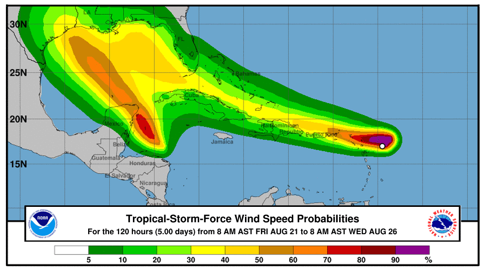
The image below is from the article, but don't let it make you think that the Gulf coast might be spared any significant winds. It is just that the five day forecast limits the probabilities to the anticipated 120 hour locations which will probably be still offshore for Laura.When two tropical cyclones approach within about 900 miles of each other, they tend to rotate counter-clockwise around a common center, then go their separate ways, in a process called the Fujiwara effect. In rare cases they may merge into one storm, but the resulting storm will not be stronger than either of the original two storms, since wind shear from each weakens the other. More commonly, when two storms interact, one will weaken or destroy the other with its wind shear, just as Hurricane Wilma did to Tropical Storm Alpha in 2005.
Some model runs have shown that Laura and TD 14 may be of similar strength and less than 900 miles apart in the Gulf of Mexico on Tuesday, resulting in a Fujiwara interaction. The 0Z Friday run of the German ICON model showed this, with TD 14 slowing its approach to the Texas coast as a result of its rotating counter-clockwise around a common center with Laura.
My father said that anything is interesting if you bother to read about it - Michael C. Harrold
-
Isgrimnur

- Posts: 82241
- Joined: Sun Oct 15, 2006 12:29 am
- Location: Chookity pok
- Contact:
-
jztemple2
- Posts: 11602
- Joined: Fri Feb 13, 2009 7:52 am
- Location: Brevard County, Florida, USA
Re: 2020 Hurricane Season
Was it the Klingons? Damn, I'm getting old, I'm forgetting my Star Trek canon.
Meanwhile, Laura shifts ever so slightly to the left/south again.

My father said that anything is interesting if you bother to read about it - Michael C. Harrold
-
jztemple2
- Posts: 11602
- Joined: Fri Feb 13, 2009 7:52 am
- Location: Brevard County, Florida, USA
Re: 2020 Hurricane Season
5pm EDT update, with fancy colors! TS Marco

And this is for TS Laura

Looks like some folks are in for a double whammie this week
And this is for TS Laura
Looks like some folks are in for a double whammie this week
My father said that anything is interesting if you bother to read about it - Michael C. Harrold
-
gilraen
- Posts: 4317
- Joined: Wed Sep 04, 2013 7:45 pm
- Location: Broomfield, CO
Re: 2020 Hurricane Season
TS Laura has now been upgraded to a hurricane and is predicted to strengthen to Category 3 as it moves over very warm waters in the Gulf of Mexico today and tomorrow.
-
jztemple2
- Posts: 11602
- Joined: Fri Feb 13, 2009 7:52 am
- Location: Brevard County, Florida, USA
Re: 2020 Hurricane Season
Thankfully Laura had no effect on our trip to Fort Myers on Sunday and we were able to celebrate my wife’s birthday with a nice evening out at the Broadway Palm dinner theater. It was even pleasantly breezy the next day.
Bad luck for southern Louisiana as it seems Marco didn’t do much to cool off the Gulf surface temps.
Bad luck for southern Louisiana as it seems Marco didn’t do much to cool off the Gulf surface temps.
My father said that anything is interesting if you bother to read about it - Michael C. Harrold
-
jztemple2
- Posts: 11602
- Joined: Fri Feb 13, 2009 7:52 am
- Location: Brevard County, Florida, USA
Re: 2020 Hurricane Season
My father said that anything is interesting if you bother to read about it - Michael C. Harrold
-
pr0ner

- Posts: 17429
- Joined: Mon Dec 06, 2004 3:00 pm
- Location: Northern Virginia, VA
- Contact:
Re: 2020 Hurricane Season
Hodor.
-
jztemple2
- Posts: 11602
- Joined: Fri Feb 13, 2009 7:52 am
- Location: Brevard County, Florida, USA
Re: 2020 Hurricane Season
Key messages from the National Hurricane Center at 10am CDT (click to enlarge)

My father said that anything is interesting if you bother to read about it - Michael C. Harrold
-
Smoove_B

- Posts: 54653
- Joined: Wed Oct 13, 2004 12:58 am
- Location: Kaer Morhen
Re: 2020 Hurricane Season
"Unsurvivable" is not language you want to read going into a hurricane.
Maybe next year, maybe no go
-
jztemple2
- Posts: 11602
- Joined: Fri Feb 13, 2009 7:52 am
- Location: Brevard County, Florida, USA
Re: 2020 Hurricane Season
Our local 24 news channel is reporting that they expect Laura to intensify to a Cat 4 then drop back to a Cat 3 at landfall. He noted that there's not that much difference between the two, it's still going to be really bad. Laura is expected to reach northern Louisiana still as a Cat 1 hurricane, even a couple of hundred miles inland.
My father said that anything is interesting if you bother to read about it - Michael C. Harrold
-
Isgrimnur
- Posts: 82241
- Joined: Sun Oct 15, 2006 12:29 am
- Location: Chookity pok
- Contact:
Re: 2020 Hurricane Season
I mean people see a few feet, and don't think about how much water that is and the forces that come with it.
It's almost as if people are the problem.
-
gilraen
- Posts: 4317
- Joined: Wed Sep 04, 2013 7:45 pm
- Location: Broomfield, CO
Re: 2020 Hurricane Season
It's absolutely massive as seen from space:
-
Daehawk

- Posts: 63669
- Joined: Sat Jan 01, 2005 1:11 am
Re: 2020 Hurricane Season
Worst thing is its going right up the river with all that rain.
Neat pic. I remember hurricanes like Gilbert and Harvey that completely filled up the Gulf of Mexico. Huge storms.
Neat pic. I remember hurricanes like Gilbert and Harvey that completely filled up the Gulf of Mexico. Huge storms.
--------------------------------------------
I am Dyslexic of Borg, prepare to have your ass laminated.
I guess Ray Butts has ate his last pancake.
http://steamcommunity.com/id/daehawk
"Has high IQ. Refuses to apply it"
I am Dyslexic of Borg, prepare to have your ass laminated.
I guess Ray Butts has ate his last pancake.
http://steamcommunity.com/id/daehawk
"Has high IQ. Refuses to apply it"
-
Enough

- Posts: 14688
- Joined: Tue Oct 12, 2004 11:05 pm
- Location: Serendipity
- Contact:
Re: 2020 Hurricane Season
This storm is bonkers, it could really end up being quite the historic hit. Imagine if this hit Houston directly and the 100s of billions in damages. That said, it's heading into an area rife with industrial infrastructure like refineries and such with at least over 500k people living in an area likely to get some decent wind. Buckle up.
My blog (mostly photos): Fort Ephemera - My Flickr Photostream
“You only get one sunrise and one sunset a day, and you only get so many days on the planet. A good photographer does the math and doesn’t waste either.” ―Galen Rowell
“You only get one sunrise and one sunset a day, and you only get so many days on the planet. A good photographer does the math and doesn’t waste either.” ―Galen Rowell
-
malchior
- Posts: 24795
- Joined: Wed Oct 13, 2004 12:58 pm
Re: 2020 Hurricane Season
I'm dealing with some of these folks in O&G. It went from...we're shutting down and can't go in ... to we look like we're clear ... to *we're fucked* in the span of like 3 days. Especially once it started becoming clear it might be coming ashore at *140* sustained!?!Enough wrote: ↑Wed Aug 26, 2020 2:16 pm This storm is bonkers, it could really end up being quite the historic hit. Imagine if this hit Houston directly and the 100s of billions in damages. That said, it's heading into an area rife with industrial infrastructure like refineries and such with at least over 500k people living in an area likely to get some decent wind. Buckle up.
-
Smoove_B
- Posts: 54653
- Joined: Wed Oct 13, 2004 12:58 am
- Location: Kaer Morhen
Re: 2020 Hurricane Season
If I'm to believe the experts, it's going to cause irreparable damage where ever it lands, likely causing widespread power loss and service interruption for *months*. By all accounts this will be a humanitarian crisis, during a pandemic, while CA burns. I keep saying "worst case scenario" but it keeps getting worse.Enough wrote: ↑Wed Aug 26, 2020 2:16 pm This storm is bonkers, it could really end up being quite the historic hit. Imagine if this hit Houston directly and the 100s of billions in damages. That said, it's heading into an area rife with industrial infrastructure like refineries and such with at least over 500k people living in an area likely to get some decent wind. Buckle up.
EDIT: Fret forgive me
Last edited by Smoove_B on Wed Aug 26, 2020 2:52 pm, edited 1 time in total.
Maybe next year, maybe no go
-
Enough
- Posts: 14688
- Joined: Tue Oct 12, 2004 11:05 pm
- Location: Serendipity
- Contact:
Re: 2020 Hurricane Season
Hurricane Harvey is a pretty good analog for this storm, but it could eclipse that one if it keeps intensifying. Storm surge is potentially going to be record-setting for this part of the GOM (Katrina will likely not be matched):
https://twitter.com/EricBlake12/status/ ... 9242788867
Note all the surge right around the nation's largest refinery at Port Arthur (Sabine Lake 10-15 ft).
https://twitter.com/EricBlake12/status/ ... 9242788867
Note all the surge right around the nation's largest refinery at Port Arthur (Sabine Lake 10-15 ft).
Spoiler:
My blog (mostly photos): Fort Ephemera - My Flickr Photostream
“You only get one sunrise and one sunset a day, and you only get so many days on the planet. A good photographer does the math and doesn’t waste either.” ―Galen Rowell
“You only get one sunrise and one sunset a day, and you only get so many days on the planet. A good photographer does the math and doesn’t waste either.” ―Galen Rowell
-
Enough
- Posts: 14688
- Joined: Tue Oct 12, 2004 11:05 pm
- Location: Serendipity
- Contact:
Re: 2020 Hurricane Season
Getting a good look at the clearing eye, can you say textbook stadium effect?
https://twitter.com/weatherdak/status/1 ... 5434801152
https://twitter.com/weatherdak/status/1 ... 5434801152
My blog (mostly photos): Fort Ephemera - My Flickr Photostream
“You only get one sunrise and one sunset a day, and you only get so many days on the planet. A good photographer does the math and doesn’t waste either.” ―Galen Rowell
“You only get one sunrise and one sunset a day, and you only get so many days on the planet. A good photographer does the math and doesn’t waste either.” ―Galen Rowell
-
Enough
- Posts: 14688
- Joined: Tue Oct 12, 2004 11:05 pm
- Location: Serendipity
- Contact:
Re: 2020 Hurricane Season
It's gonna make a run at Cat 5. What really sucks is that although the population of cities most likely to be hit is small in comparison to some alternatives (Lake Charles 80,000ish, Port Arthur has about 55,000), both cities have 20%+ of their population living below the poverty line. I sure hope evacuation is effective, I fear this is going to get really bad.

My blog (mostly photos): Fort Ephemera - My Flickr Photostream
“You only get one sunrise and one sunset a day, and you only get so many days on the planet. A good photographer does the math and doesn’t waste either.” ―Galen Rowell
“You only get one sunrise and one sunset a day, and you only get so many days on the planet. A good photographer does the math and doesn’t waste either.” ―Galen Rowell
-
Enough
- Posts: 14688
- Joined: Tue Oct 12, 2004 11:05 pm
- Location: Serendipity
- Contact:
Re: 2020 Hurricane Season
Steaming link for Weather Channel live stream: https://watchnewslive.tv/the-weather-ch ... ve-stream/
Local Baton Rouge TV: https://www.wafb.com/live/
Super high-res visible sat view (will refresh new images with a hard refresh: https://cdn.star.nesdis.noaa.gov/GOES16 ... 0x2000.jpg
Weather nerd delight radar: https://weather.cod.edu/satrad/?parms=m ... =undefined
Same radar site but visible with lightning (which sadly is still firing like mad near the eye): https://weather.cod.edu/satrad/?parms=s ... =undefined
My blog (mostly photos): Fort Ephemera - My Flickr Photostream
“You only get one sunrise and one sunset a day, and you only get so many days on the planet. A good photographer does the math and doesn’t waste either.” ―Galen Rowell
“You only get one sunrise and one sunset a day, and you only get so many days on the planet. A good photographer does the math and doesn’t waste either.” ―Galen Rowell
-
Enough
- Posts: 14688
- Joined: Tue Oct 12, 2004 11:05 pm
- Location: Serendipity
- Contact:
Re: 2020 Hurricane Season
There's a slight bit of sheer that might help right before landfall, but the most recent Hurricane Hunter flight data shows 145-150 mph surface winds and 180mph winds aloft in the NE QUAD. Yikesters.
My blog (mostly photos): Fort Ephemera - My Flickr Photostream
“You only get one sunrise and one sunset a day, and you only get so many days on the planet. A good photographer does the math and doesn’t waste either.” ―Galen Rowell
“You only get one sunrise and one sunset a day, and you only get so many days on the planet. A good photographer does the math and doesn’t waste either.” ―Galen Rowell
-
Enough
- Posts: 14688
- Joined: Tue Oct 12, 2004 11:05 pm
- Location: Serendipity
- Contact:
Re: 2020 Hurricane Season
Latest update brings peak winds to 150mph, pressure down to 940mb (just barely beneath Cat 5). Laura is set to be the most powerful hurricane to strike southwestern Louisiana, dating to at least the 1850s.
My blog (mostly photos): Fort Ephemera - My Flickr Photostream
“You only get one sunrise and one sunset a day, and you only get so many days on the planet. A good photographer does the math and doesn’t waste either.” ―Galen Rowell
“You only get one sunrise and one sunset a day, and you only get so many days on the planet. A good photographer does the math and doesn’t waste either.” ―Galen Rowell
-
Holman

- Posts: 28958
- Joined: Sun Oct 24, 2004 8:00 pm
- Location: Between the Schuylkill and the Wissahickon
Re: 2020 Hurricane Season
This looks awful.
I just talked to my parents, who are on Mobile Bay. They won't get serious weather, but they have friends in SW Louisiana who've evacuated and aren't sure whether they'll see their homes again.
I just talked to my parents, who are on Mobile Bay. They won't get serious weather, but they have friends in SW Louisiana who've evacuated and aren't sure whether they'll see their homes again.
Much prefer my Nazis Nuremberged.
-
Enough
- Posts: 14688
- Joined: Tue Oct 12, 2004 11:05 pm
- Location: Serendipity
- Contact:
Re: 2020 Hurricane Season
My earlier comparison with Charley was apt in many ways in terms of the wind speed/pressure relationship but I should clarify that Laura is a much larger wind field and much greater surge threat. I mean hurricane winds could extend for 120 miles of the coast and serious wind events could occur all the way inland to I-20. And it's coming on shore at night. There will be massive power outages well inland later in the storm along with flash flooding from rain, but the biggest impacts will be the absolute obliteration of the Louisiana coast from surge and the hardcore winds as the eyewall hits the coast. This is utterly terrifying and getting scarier by the minute. All that said, put this sucker 100 miles west and we could be looking at the worst natural disaster in US history.
My blog (mostly photos): Fort Ephemera - My Flickr Photostream
“You only get one sunrise and one sunset a day, and you only get so many days on the planet. A good photographer does the math and doesn’t waste either.” ―Galen Rowell
“You only get one sunrise and one sunset a day, and you only get so many days on the planet. A good photographer does the math and doesn’t waste either.” ―Galen Rowell
-
em2nought

- Posts: 5349
- Joined: Fri Oct 15, 2004 5:48 am
Re: 2020 Hurricane Season
Whoa, this one blew up fast. The weather channel kinda ignored this one until now.
Stop funding for NPR
-
malchior
- Posts: 24795
- Joined: Wed Oct 13, 2004 12:58 pm
Re: 2020 Hurricane Season
It's also seems to be moving pretty slow which isn't great either. It's gonna keep picking up energy for a few more hours at least. They are talking the surge will go in-land 30-40 *miles*.
-
jztemple2
- Posts: 11602
- Joined: Fri Feb 13, 2009 7:52 am
- Location: Brevard County, Florida, USA
Re: 2020 Hurricane Season
Our local power company, Florida Power& Light, has sent 300 employees to help once the storm has passed.
My father said that anything is interesting if you bother to read about it - Michael C. Harrold
-
miltonite

- Posts: 3276
- Joined: Fri Jan 21, 2005 12:37 am
- Location: Louisiana
Re: 2020 Hurricane Season
Me and Arcanis are in Lafayette, while we should be spared the brunt we are still going to get a lot of wind and just as much rain. Lake Charles and Cameron Parish will never be the same after this.
Our local weatherman has stated that this is the first time he heard the term "Unsurvivable storm surge". From what they said, most people were out early today and most roads going out of Cameron Parish were mostly clear.
They just closed a large section if I-10.
Here is a link to our local station that is streaming their hurricane coverage if anyone is interested.
"Only in a geek forum could we talk about the camcorder's battery life ruining our suspension of disbelief, while totally accepting the gigantic impenetrable monster." -YK
"Isg, set research engines to ludicrous speed!!" -DD*
"Isg, set research engines to ludicrous speed!!" -DD*
-
Enough
- Posts: 14688
- Joined: Tue Oct 12, 2004 11:05 pm
- Location: Serendipity
- Contact:
Re: 2020 Hurricane Season
Thanks for checking in, I know we have a few OOers in the general area. I just saw this crushing news,
https://twitter.com/MelindaDeslatte/sta ... 1466674178
Cameron Parish is likely going to be completely underwater with that "unsurvivable surge," ugh.
https://twitter.com/MelindaDeslatte/sta ... 1466674178
Spoiler:
My blog (mostly photos): Fort Ephemera - My Flickr Photostream
“You only get one sunrise and one sunset a day, and you only get so many days on the planet. A good photographer does the math and doesn’t waste either.” ―Galen Rowell
“You only get one sunrise and one sunset a day, and you only get so many days on the planet. A good photographer does the math and doesn’t waste either.” ―Galen Rowell
-
Daehawk
- Posts: 63669
- Joined: Sat Jan 01, 2005 1:11 am
Re: 2020 Hurricane Season
Even our local weatherman is saying unsurvivable. Predicting 15-20 foot storm surge with 15-20 waves on top of that and then 100 mph winds. I thought there were worse and bigger one than this but I dont recall words li!e those used. Cant believe people keep living in Louisana .
--------------------------------------------
I am Dyslexic of Borg, prepare to have your ass laminated.
I guess Ray Butts has ate his last pancake.
http://steamcommunity.com/id/daehawk
"Has high IQ. Refuses to apply it"
I am Dyslexic of Borg, prepare to have your ass laminated.
I guess Ray Butts has ate his last pancake.
http://steamcommunity.com/id/daehawk
"Has high IQ. Refuses to apply it"
-
Kraken

- Posts: 43763
- Joined: Tue Oct 12, 2004 11:59 pm
- Location: The Hub of the Universe
- Contact:
Re: 2020 Hurricane Season
Then you don't recall Katrina. This is from Wiki:
MOST OF THE AREA WILL BE UNINHABITABLE FOR WEEKS...PERHAPS LONGER. AT LEAST ONE HALF OF WELL CONSTRUCTED HOMES WILL HAVE ROOF AND WALL FAILURE. ALL GABLED ROOFS WILL FAIL...LEAVING THOSE HOMES SEVERELY DAMAGED OR DESTROYED.
THE MAJORITY OF INDUSTRIAL BUILDINGS WILL BECOME NON FUNCTIONAL. PARTIAL TO COMPLETE WALL AND ROOF FAILURE IS EXPECTED. ALL WOOD FRAMED LOW RISING APARTMENT BUILDINGS WILL BE DESTROYED. CONCRETE BLOCK LOW RISE APARTMENTS WILL SUSTAIN MAJOR DAMAGE...INCLUDING SOME WALL AND ROOF FAILURE.
HIGH RISE OFFICE AND APARTMENT BUILDINGS WILL SWAY DANGEROUSLY...A FEW TO THE POINT OF TOTAL COLLAPSE. ALL WINDOWS WILL BLOW OUT.
AIRBORNE DEBRIS WILL BE WIDESPREAD...AND MAY INCLUDE HEAVY ITEMS SUCH AS HOUSEHOLD APPLIANCES AND EVEN LIGHT VEHICLES. SPORT UTILITY VEHICLES AND LIGHT TRUCKS WILL BE MOVED. THE BLOWN DEBRIS WILL CREATE ADDITIONAL DESTRUCTION. PERSONS...PETS...AND LIVESTOCK EXPOSED TO THE WINDS WILL FACE CERTAIN DEATH IF STRUCK.
POWER OUTAGES WILL LAST FOR WEEKS...AS MOST POWER POLES WILL BE DOWN AND TRANSFORMERS DESTROYED. WATER SHORTAGES WILL MAKE HUMAN SUFFERING INCREDIBLE BY MODERN STANDARDS.
THE VAST MAJORITY OF NATIVE TREES WILL BE SNAPPED OR UPROOTED. ONLY THE HEARTIEST WILL REMAIN STANDING...BUT BE TOTALLY DEFOLIATED. FEW CROPS WILL REMAIN. LIVESTOCK LEFT EXPOSED TO THE WINDS WILL BE KILLED.
-
jztemple2
- Posts: 11602
- Joined: Fri Feb 13, 2009 7:52 am
- Location: Brevard County, Florida, USA
Re: 2020 Hurricane Season
I live in east central Florida, about fifteen miles from the coast, we go through concerns about storms like this every year. Last year it was Hurricane Dorian which looked like it was going to come ashore a hundred miles or so south of here at Cat 4 strength, but stalled over the Bahamas and eventually went north passing by offshore. All you can do is prepare your hurricane kit, watch the weather and plan ahead whether you are going to evacuate if something even looks close to coming your way. We evacuated to Tallahassee a couple of days before Dorian even hit the Bahamas.
My father said that anything is interesting if you bother to read about it - Michael C. Harrold
-
Enough
- Posts: 14688
- Joined: Tue Oct 12, 2004 11:05 pm
- Location: Serendipity
- Contact:
Re: 2020 Hurricane Season
My blog (mostly photos): Fort Ephemera - My Flickr Photostream
“You only get one sunrise and one sunset a day, and you only get so many days on the planet. A good photographer does the math and doesn’t waste either.” ―Galen Rowell
“You only get one sunrise and one sunset a day, and you only get so many days on the planet. A good photographer does the math and doesn’t waste either.” ―Galen Rowell
-
Isgrimnur
- Posts: 82241
- Joined: Sun Oct 15, 2006 12:29 am
- Location: Chookity pok
- Contact:

-
Jaymann

- Posts: 19454
- Joined: Mon Oct 25, 2004 7:13 pm
- Location: California
Re: 2020 Hurricane Season
Jaymann
]==(:::::::::::::>
Black Lives Matter
]==(:::::::::::::>
Black Lives Matter
-
Blackhawk

- Posts: 43804
- Joined: Tue Oct 12, 2004 9:48 pm
- Location: Southwest Indiana
Re: 2020 Hurricane Season
Bad advice. Turbulent water sometimes removes clothing from bodies.
(˙pǝsɹǝʌǝɹ uǝǝq sɐɥ ʎʇıʌɐɹƃ ʃɐuosɹǝd ʎW)
-
Isgrimnur
- Posts: 82241
- Joined: Sun Oct 15, 2006 12:29 am
- Location: Chookity pok
- Contact:
Re: 2020 Hurricane Season
Looks like it's almost all into Arkansas now.
It's almost as if people are the problem.